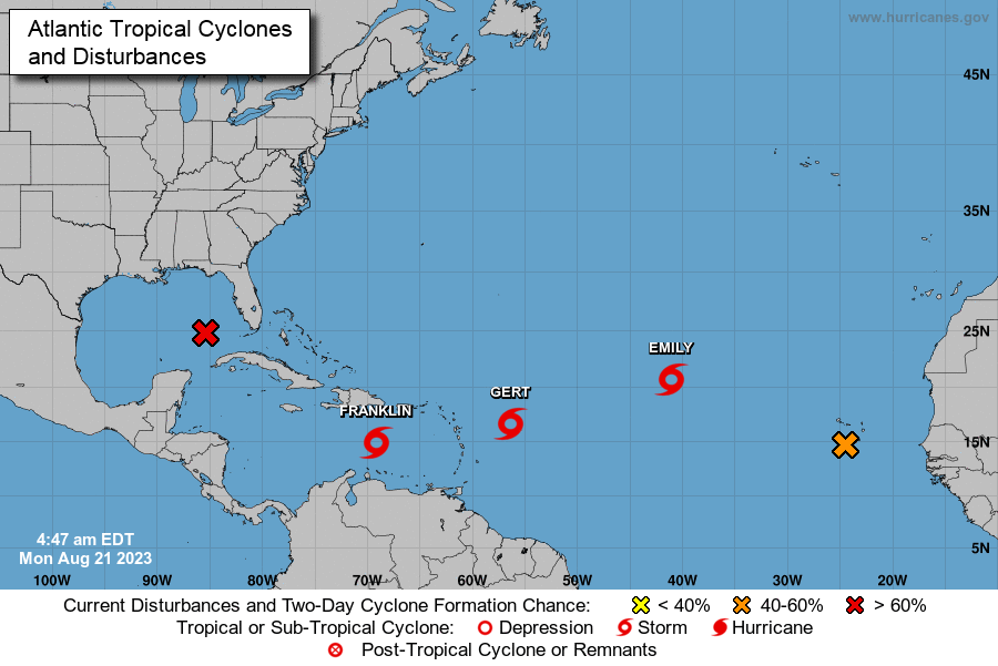
MIAMI, FL (352today.com) – Despite a relatively quiet summer, the tropics are starting to get active as we near the end of August. Three named storms have now formed, according to the 2 a.m. ET update Monday from the National Hurricane Center (NHC). They are Tropical Storms Emily, Franklin and Gert.
Activity intensified over the weekend with the NHC monitoring a total of five systems.
Tropical Storm Gert Quickly Unraveling
Tropical Storm Gert formed early Monday just hours after two other tropical storms – Franklin and Emily formed Sunday. The NHC says Gert briefly intensified overnight but is quickly unraveling Monday morning. As of 4 a.m. EST, Gert was located 455 miles east-southeast of the northern Leeward Islands with maximum sustained winds of 40 mph and moving west at nine mph. Tropical storm force winds extend 70 miles from the storm’s center. Gert is not expected to be a troublemaker. The 4 a.m. forecast discussion indicated, “The surface circulation is becoming ill-defined while the associated sheared mass of convection is shrinking.” The storm is predicted to be downgraded to a remnant low by Monday evening and dissipate by Tuesday.
Tropical Storm Emily Weaking
Tropical Storm Emily formed on Sunday. As of 4 a.m. EST, the storm was located more than 1,110 miles west-northwest of the Cabo Verde Islands and moving west-northwest at 12 mph. Maximum sustained winds decreased to near 40 mph with some higher gusts. Tropical storm force winds extend out more than 200 miles. Further weakening is forecast, and Emily should become a post-tropical cyclone by Monday evening.
Tropical Storm Franklin Could Become a Hurricane
Of the three storms, Franklin is the only one the NHC predicts will impact land. As of 4 a.m. EST, Franklin was located about 240 miles south of Santo Domingo, the capital city of the Dominican Republic, and moving west at 12 mph. Franklin’s maximum sustained winds clock in at 50 mph. Franklin is expected to bring tropical storm conditions to portions of the Dominican Republic and Haiti starting on Tuesday where Tropical Storm Warnings are in effect. After that, Franklin is expected to dump heavy rainfall across portions of Puerto Rico and Hispaniola through the middle of the week. Franklin is expected to strengthen and likely become a hurricane within the next five days. The NHC forecast discussion says, “The current thinking is that the shear will not be strong enough to prevent the system from eventually becoming a hurricane over the southwest Atlantic.”
There’s still much more time left in the 2023 Atlantic hurricane season which ends November 30. The next named storm to form would be called Harold.


